

ΠΕΡΙΛΗΨΗ
Σε οικόπεδο συνολικής εκτάσεως περίπου 40 στρεμμάτων στη θέση ΠΟΤΑ Ρωμανού (Περιοχή Οργανωμένης Τουριστικής Ανάπτυξης) διενεργήθηκαν από την Εφορεία Αρχαιοτήτων Μεσσηνίας και υπό την επίβλεψη της αρχαιολόγου Ευαγγελίας Μαλαπάνη εκτεταμένες δοκιμαστικές τομές, έπειτα από αίτημα της ΤΕΜΕΣ Α.Ε. για την κατασκευή αθλητικών εγκαταστάσεων. Κατά την ανασκαφική διερεύνηση των τομών αποκαλύφθηκαν σε όλη σχεδόν την έκταση του οικοπέδου αρχαιότητες, οι οποίες χρονολογούνται από την Πρώιμη Eποχή του Χαλκού έως τους ύστερους ρωμαϊκούς χρόνους. Η ανασκαφική διερεύνηση του οικοπέδου, η οποία έγινε σε συνεργασία με την αρχαιολόγο Sharon Stocker και την ομάδα της, αποκάλυψε οικιστικά κατάλοιπα που ανήκουν σε εκτεταμένο οικισμό της ΠΕ ΙΙ περιόδου, ο οποίος αποτελούσε συνέχεια του μεγάλου πρωτοελλαδικού οικισμού που ερεύνησε το 2007-2011 ο Jörg Rambach στην περιοχή του ξενοδοχειακού συγκροτήματος Costa Navarino. Η ανασκαφική έρευνα αποκάλυψε επίσης ταφικό πίθο της ΜΕ εποχής, καθώς και γεωμετρικό ταφικό πίθο, ο οποίος περιείχε μια πρωτογενή ταφή άνδρα και μια δευτερογενή ταφή γυναίκας. Επιπλέον, σε πιθάρι της ΠΕ ΙΙ εποχής βρέθηκε μεγάλος αριθμός κουκουτσιών σταφυλιού, τα οποία αποτελούν την παλαιότερη, μέχρι σήμερα, μαρτυρία για την καλλιέργεια της αμπέλου στη Μεσσηνία.
Introduction
In the fall of 2014, the Ephorate of Antiquities of Messenia investigated a large plot of land where the developers of the Costa Navarino Resort intended to construct professional football facilities. The location of the field is adjacent to the southeastern boundary of the resort, near the edge of the modern village of Romanou in the province of Pylia in western Messenia.
In October of that year, 32 test trenches were dug in the field under the supervision of Dr. Evangelia Malapani on behalf of the Ephorate of Antiquities of Messenia; archaeological material of Bronze Age, Classical, and Roman date was found1 . Rescue excavations were then conducted here by Malapani, assisted by archaeologist Anna Michopoulou. At the beginning of February 2015, the Ephorate, in cooperation with Dr. Sharon Stocker, Dr. Calla McNamee, and Dr. Salvatore Vitale, with assistance from Dionysia Giannakopoulou and others, undertook mapping, documentation, and further excavation of the site.
The area investigated is bounded to the north by the Selas River, to the west by a fence that delimits the current boundary of the Costa Navarino golf course (at the 15th and 16th holes) and by a privately owned olive grove, and to the east and south by the road that leads to the modern village of Romanou (fig. 1). The field, which comprises almost 40 acres, is overgrown with maquis and dense scrub amid olives.

While Michopoulou was excavating under the direction of Malapani in the southeast corner of the plot, a surface survey was conducted around the trial trenches in order to determine overall artifact densities. Heavy concentrations of Early Helladic (EH) II material were mapped in several areas, and in places there were also high densities of lithics, primarily obsidian. In addition to EH II, material of Classical to Roman date was found, as well as a large quantity of non-diagnostic tiles, most probably of Hellenistic, Roman, and Modern date.
Possible Geometric graves were found at the northeastern extremity of the plot and Roman graves in the southeastern. It was determined that, among other things, the field had been part of a very large settlement of the EH period, an extension of the one previously investigated by Dr. Jörg Rambach, and now buried beneath the 15th and 16th holes of the golf course2.
The excavation
Little was known of the EH period in western Messenia prior to excavations on the Costa Navarino property.
In the 1990s, the Pylos Regional Archaeological Project had identified EH II ceramics at several locations, among them Vergina Rema, Vromoneri Nozaina, and the site under discussion, Romanou3. EH II material has also been excavated at Voidokoilia by Prof. Georgios Korres4. However, it is now clear that the Romanou settlement was the principal Early Helladic site in western Messenia, considerably larger and more complex than Voidokoilia.
The main part of the EH II site at Romanou appears to be situated in the area investigated from 2007-2011 by Rambach on behalf of the 38th Ephorate of Prehistoric and Classical Antiquities. He found there, among other things, streets with houses on either side, a collapsed well containing hundreds of EH II pottery vessels5, a building used for the smelting of copper and the production of bronze, and an obsidian workshop. A probable storage facility with numerous pithoi, a few of which contained grape pips or some other fruit, perhaps figs, was excavated at the southern corner of the golf course along the fence dividing it from the plot under discussion.
Rambach was able to identify four subphases of the EH period. In the course of his work, however, he was unable to determine the southern and eastern boundaries of the site because it extended to areas beyond the golf course. Our work suggests that we have located part of the eastern boundary. The southern boundary is still undetermined, but, all told, the minimum size of the EH II site at Romanou must have been a staggering 5.5 hectares.
Beginning in May 2015, Hüseyin Öztürk acted as field supervisor of excavations, under the direction of Malapani and Stocker. Work continued until July of 2015. It was subsequently determined that the Costa Navarino Resort would need to modify its building plan to take into account and protect the substantial EH remains that were uncovered during the course of our investigations. Three particular locations were selected for continued excavation to supplement information from the trial trenches and surface survey.

Area B
The first of these, Area B, was explored in May-July 2015 at the central western edge of the field on a piece of flat land previously used for greenhouse agriculture (fig. 2). Large stones were uncovered there during testtrenching, and it was believed they might belong to architectural structures. Shallow EH II floor deposits lay just beneath the surface, resting near bedrock within rooms defined by stone walls with mudbrick superstructures.
Although the area was free from the tree roots that caused disturbances in most other places, truncations resulting from modern agricultural activities proved to be problematic. Several walls were found in Area B, although their relationship to one another is as yet unclear. None had foundation trenches, so they were likely socles for a mudbrick superstructure built on the prehistoric ground level. No floors were detected during excavation, suggesting that they were of packed earth and are indistinguishable from the surrounding soil matrix. Micromorphological samples, however, were taken by McNamee for analysis by Dr. Takis Karkanas and should prove useful in determining where floors existed.
Traces of fire and burning were detected, especially along the wall in trench B04, where there was a high concentration of pottery fragments, charcoal, and occasional animal bones.
The longest wall in Area B (11.5 m in length) runs approximately NE-SW and is composed of several different, but likely related, sections (fig. 3). The northeast section, in Trench B03, actually consists of two walls adjacent to one another. Although the walls made use of different sizes of stones, they might have been built at the same time, and were all in use during the late EH II period. In each case, walls in Area B were only one course high, and plentiful evidence for destruction by fire was found associated with them. The pottery, for the most part, dates to the final phase of the EH II period and consists of non-joining fragments of coarse and fine wares, suggesting that Area B was either a refuse dump or an exterior space. An earlier phase of late EH II is represented by material from a pit in Trench B05.


A pithos burial of the Early Iron Age in Area B had been set into an Early Helladic II wall. It had been placed on its side and the mouth blocked by several stones and the rim of an older pithos (fig. 4). The jar contained two bodies: the partly articulated skeleton of a young female in an extreme flexed position and the incomplete skeleton of a middle-aged male (fig. 5). It appears that the male was buried first and parts of his skeleton removed when the female was added at a later date6.
Grave goods that accompanied the burials consisted of two complete skyphoi and two iron nails (fig. 6) found in the centre of the pithos. The surface of these vessels is heavily eroded; one skyphos bears faint traces of dark lustrous paint near the handles, while the other preserves no traces of the original decoration. The skyphoi date the burial to the mature Geometric period, possibly in Coulson’s DA II-III or DA III phase7.


Area C
Area C consists of a large pithos burial excavated in March and April 2015. That pithos, surrounded by a stone cairn of irregular shape, had been placed on its side with its mouth facing north and closed with stone slabs. One skeleton, unaccompanied by grave goods, was found inside in a contracted position (fig. 7). The absence of grave goods makes it difficult to date the burial although the characteristics of the pithos suggest it is MH in date.

Area E
Area E was explored in the southeast part of the field in May-July 2015. It is bounded to the south by the paved road to Romanou and to the east by the gravel road that runs through the property. Stone walls and a high concentration of material were revealed by a test trench, leading to further excavation. The nine trenches established here fall into two categories (fig. 8): the six western trenches contain walls of structures and appear to represent interior space (E01, 03, 05, 07, 08, 09) and the three eastern trenches appear to be exterior space and include a possible refuse dump (E02, 04, 06). The entire area was destroyed by fire.
The main structure, dubbed the ‘Pithos House’ because of the remains of pitharia found inside, was initially defined by three walls in Trenches E01, 03, 05, and 07. Two of the walls run N/NE-S/SW, the other NW-SE. We are not entirely certain that all three walls belong to the same structure. The space, whether a room or not, contained a final EH II destruction deposit consisting of numerous complete or nearly complete fine and coarse vessels and large fragments of burnt mudbrick. The material appears to rest on an occupation surface, although no floor was detected. Again, we believe that micromorphology samples will help us to define the exact level of the floor.
The mendable vessels in the north portion of the defined space differ from those in the south. Primarily semi-coarse and coarse wares were found in Trench E01, suggesting that this part of the space was used for storage. Two bronze pins or nails were also discovered here. The southern space, Trench E03, on the other hand, contained an abundance of highly mendable vessels consisting almost exclusively of table wares, principally plain saucers and a few sauceboats (fig. 9). The wall that runs through this trench in a NE-SW direction continues into Trench E07 and then disappears into the southern scarp.
Trench E08 contains a wall that abruptly terminates at its northeastern end. The area to the north side of the wall contained degraded mudbrick and a few non-mendable sherds, suggesting that this was exterior space. The material to the south of the wall, however, corresponds to that found in Trench E03 and consisted primarily of numerous mendable fine ware vessels.
A circular limestone feature, defined as Trench E09, occupies the middle of the space. It remains unclear as to whether this is an entirely natural feature or has been shaped by human intervention. An attempt to excavate inside the circular opening was hindered by the narrowness of the space and compactness of the earth.
Excavation here could not be completed due to time constraints.
As noted above and based on our current understanding of the walls in the western half of Area E, Trenches E02, 04, and 06 are believed to be exterior spaces. E04 and 06 produced very little material, none of which was mendable, and no remains of architecture. The material in Trench E02 appears to be part of a destruction deposit left in a refuse dump. The soil here was dark and silty compared to that elsewhere on the site, which likely resulted from the decomposition of organic materials.
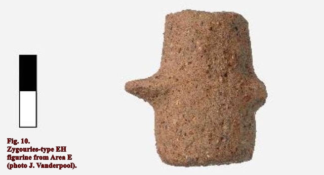
E02 contained a large quantity of material, most of which was not mendable and, in the southwest corner, two EH II Zygouries-type figurines (fig. 10)8. Four nearly intact mudbricks were aligned in a row along the southern edge. Also, in the trench was the complete base of a pithos. Archaeobotanical samples from the soil beneath the pithos produced a very large quantity of grape pips, identified by Dr. Tania Valamoti and her colleagues. This deposit constitutes the earliest evidence for cultivation of the grape in the western Peloponnese9.


In conclusion, we believe that the part of the site that we have investigated represents the eastern edge of the large EH II settlement of Romanou. Only one occupation phase is represented in Area E, suggesting that that location was probably not settled in the first phases of the EH II, but only occupied as population increased and the site expanded. It is significant that we did not recover the fine decorated dark-on-light and pattern painted wares found by Rambach under the 15th and 16th holes of the golf course.
EVANGELIA MALAPANI – SHARON STOCKER – SALVATORE VITALE – CALLA MCNAMEE
HÜSEYIN ÖZTÜRK – ANNA MICHOPOULOU
Excavations at the Early Helladic site at POTA Romanou 2014-2015
ΑΕΠΕΛ2. Πρακτικά της Β΄ Επιστημονικής Συνάντησης Καλαμάτα, 1-4 Νοεμβρίου 2017
1 We express special thanks to Evangelia Militsi, Director of the Ephorate of Antiquities of Messenia, Jack Davis, Takis Karkanas, Thomas Brogan, Evangelia Kiriatzi, Tania Valamoti, Lynne Schepartz, Vasilis Panou, Vicky Andrianopoulou, Denitsa Nenova, and Tina Ross.
2 Rambach 2010. Rambach 2014.
3 Davis – Bennet 2017, 35-36, 38-39, 45, 96-98, 123-125, 535-539.
4 Κορρές 1978, 311-343.
5 Rambach 2016. Rambach 2018. Kordatzaki et al. 2018.
6 We are grateful to Ioanna Moutafi, then attached to the Wiener Laboratory of the American School of Classical Studies at Athens, for excavating most of these burials and to Lynne Schepartz of the University of Witwatersrand for examining them.
7 Coulson 1983, 96-109.
8 Blegen 1928, 1879 Valamoti et al. 2020.
BIBLIOGRAPHY
Blegen 1928: C. W. Blegen, Zygouries: A Prehistoric Settlement in the Valley of Cleonae, Cambridge, Mass. 1928.
Coulson 1983: W. D. E. Coulson, The Pottery, in W. A. McDonald – W. D. E. Coulson – J. Rosser (eds), Excavation at Nichoria in Southwest Greece III. The Dark Age and Byzantine Occupation, Minneapolis 1983, 61-259.
Davis – Bennet 2017: J. L. Davis – J. Bennet, The Pylos Regional Archaeological Project: A Retrospective, Princeton 2017.
Kordatzaki et al. 2018: G. Kordatzaki – E. Kiriatzi – J. Rambach, Ceramic traditions in Southwestern Peloponnese during the EH II Period: The Romanos Pylias case study, in: E. Alram-Stern – B. Horejs (eds), Pottery Technologies and Sociocultural Connections Between the Aegean and Anatolia During the 3rd Millennium B.C., OREA 10, Vienna 2018, 249-266.
Κορρές 1978: Γ. Σ. Κορρές, Έρευναι και ανασκαφαί ανά την Πυλίαν, ΠΑΕ 1980, 323-360.
Rambach 2010: J. Rambach, Πρόσφατες έρευνες σε μεσοελλαδικές θέσεις της δυτικής Πελοποννήσου, in: A. Philippa- Touchais – G. Touchais – S. Voutsaki – J. Wright (eds), Mesohelladika. La Grèce continentale au Bronze Moyen, Actes du colloque international organisé par l’École française d’Athènes en collaboration avec l’American School of Classical Studies at Athens et le Netherlands Institute in Athens, Athènes, 8-12 mars 2006, BCH Supplément 52, Paris/Αthènes 2010,107-119.
Rambach 2014: J. Rambach, Σωστικές ανασκαφές στη θέση Π.Ο.Τ.Α. Ρωμανού – Costa Navarino – Navarino Dunes 2007-2010: Ρωμανός Πυλίας, Νέα στοιχεία κατοίκησης από την πρωτοελλαδική έως την ελληνιστική εποχή, in: Πρακτικά Δ΄ Τοπικού Συνεδρίου Μεσσηνιακών Σπουδών, Καλαμάτα 8-11 Οκτωβρίου 2010, ΑΘήνα 2014, 147-157.
Rambach 2016: J. Rambach, Early Helladic Romanos/Messenia: Filling a well, in: E. Alram-Stern – F. Blakolmer – S. Deger- Jalkotzy – R. Laffineur – J. Weilhartner (eds), Metaphysis: Ritual, Myth and Symbolism in the Aegean Bronze Age, Proceedings of the 15th International Aegean Conference, Vienna, Institute for Oriental and European Archaeology, Aegean and Anatolia Department, Austrian Academy of Sciences and Institute of Classical Archaeology, University of Vienna, 22-25 April 2014, Aegaeum 39, Leuven 2016, 567-570.
Valamoti et al. 2020: T. Valamoti – Cl. Pagnoux – M. Ntinou – L. Bouby – V. Bonhomme – J.-Fr. Terral, More than meets the eye: New archaeobotanical evidence on Bronze Age viticulture and wine-making in the Peloponnese, Greece, Vegetation History and Archaeobotany 29 (2020), 35-50.